
Teesdale and County Durham
Teesdale
Teesdale gets its name from the river Tees which rises in the high Pennines near the summit of Cross Fell, which at 2930ft (893m) is the highest mountain in the Pennines. The river flows through an upland landscape that is amongst the finest in the country and was designated an Area of Outstanding Natural Beauty (AONB) in 1988 to reflect this. Lower down the valley the landscape changes from rugged mountain and moorland to a more gentle landscape of woodland and fields. The images in this gallery portray a little of what Teesdale has to offer.
Teesdale gets its name from the river Tees which rises in the high Pennines near the summit of Cross Fell, which at 2930ft (893m) is the highest mountain in the Pennines. The river flows through an upland landscape that is amongst the finest in the country and was designated an Area of Outstanding Natural Beauty (AONB) in 1988 to reflect this. Lower down the valley the landscape changes from rugged mountain and moorland to a more gentle landscape of woodland and fields. The images in this gallery portray a little of what Teesdale has to offer.

03M-0120 Autumn Colours at Low Force Waterfall on the River Tees, Bowlees, County Durham. UK

03M-0133 Autumn Colours at Low Force Waterfall on the River Tees, Bowlees, County Durham. UK

Summer, Light, River, Tees, Demesnes Mill, Barnard, Castle, Teesdale, County Durham, Beautiful, Landscape, Scene, UK.

03M-8830 Autumn at Low Force on the River Tees, Near Bowlees in Upper Teesdale, County Durham UK

03M-8903 Autumn Colours Hudeshope Beck Middleton In Teesdale County Durham UK

03M-8982 Egglestone Abbey, Barnard Castle, Teesdale, County Durham.

03M-9002 Egglestone Abbey Bridge, River Tees, Barnard Castle, Teesdale, County Durham

03M-9087 Summerhill Force in Autumn Bowlees Teesdale County Durham UK

04M-2508 Harwood Beck and Wheysike House in Winter with Cronkley Fell Behind, Upper Teesdale, County Durham UK

04M-2954 Walker on Loups's Hill at Sunrise, Teesdale, County Durham UK

04M-4521 The Castle of Barnard Castle with Reflection in the River Tees, Teesdale County Durham UK

Widdybank Farm at Dawn, Upper Teesdale County Durham UK

04M-7251 Walker Enjoying the View from Goldsborough Crag, Teesdale, County Durham, UK

Misty Lunedale from the summit of Harter Fell, North Pennines County Durham UK

The North Pennine farm of Peghorn Lodge illuminated by the rising sun as mist rises in the valley below, Upper Teesdale, County Durham UK

Sunrise Over the River Tees at Holwick Head on the Pennine Way Long Distance Trail, Upper Teesdale, County Durham UK

The River Tees and Pennine Way at Low Force Bowlees Teesdale County Durham UK

The medieval ruins of Barnard Castle reflected in the River Tees in Autumn, Barnard Castle, Teesdale, County Durham, UK

Morning Light Illuminating the Ruins of Egglestone Abbey near Barnard Castle, Teesdale, County Durham UK.

Mill Falls, River Tees, Barnard Castle, Teesdale, County Durham UK.

A Mystical Summerhill Force and Bowlee Beck, Bowlees, Upper, Teesdale, County Durham, UK

Summerhill Force and Bowlee Beck, Bowlees, Upper, Teesdale, County Durham, UK

Summerhill Force and Bowlee Beck, Bowlees, Upper, Teesdale, County Durham, UK

Crepuscular Rays, Cow Green Reservoir, Upper Teesdale, County Durham UK

A spectacular sunset over Cow Green reservoir with Cross Fell and the Dun Fells illuminated by crepuscular rays, Upper Teesdale, County Durham, UK

Hiker at Sunrise on Great Stony Hill, Teesdale, County Durham UK.

2018-M3-2017 North Pennine Wild Flower Meadow, Holwick, Teesdale, County Durham UK
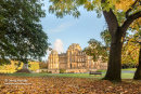
Autumn Colours, the Bowes Museum, Barnard Castle, County Durham

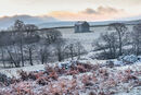
With the Dramatic Backdrop Cronkley Fell Sprindrift Streams across the Landscape and Envelops a Remote Farmhouse in Upper Teesdale, County Durham, UK

Sprindrift Streams across the Landscape and Envelops a Remote Farmhouse in Upper Teesdale, County Durham, UK

Summerhill Force Rainbow, Bowlees, Teesdale, County Durham, UK

Mill Falls in Winter, Barnard Castle, Teesdale, County Durham, UK

Rivers of Gold, Upper Teesdale, County Durham, UK

Barnard Castle and St Mary's Church in Winter, Teesdale, County Durham, Uk

Barnard Castle Viewed from the River Tees in Winter, Teesdale, County Durham, Uk

Winter Sunrise at the Bowes Museum, Barnard Castle, County Durham, UK

Winter Sunrise, Teesdale, County Durham, UK

The River Tees in Autumn, Upper Teesdale, County Durham, UK

Summerhill Force in Winter, Teesdale, County Durham, UK

Summerhill Force in Winter, Teesdale, County Durham, UK

Summerhill Force, Teesdale, County Durham, UK
Frosty Morning near Holwick, North Pennines, Teesdale, County Durham, UK

Winter Solstice Sunrise, Kirkcarrion, Teesdale, County Durham, UK

2013-01M-2979 Spring Woodland in Early Morning Light Teesdale County Durham UK

Woodland in Early Morning Light Teesdale County Durham UK

High Force in Autumn after Heavy Rain, Teesdale, County Durham, UK

Old Chaldron Wagon Wheels on the Chemical Beach at Sunrise, Durham Heritage Coast, Seaham, County Durham, UK

Old Chaldron Wagon Wheels on the Chemical Beach at Sunrise, Durham Heritage Coast, Seaham, County Durham, UK

The Chemical Beach at Sunrise, Durham Heritage Coast, Seaham, County Durham, UK

The Chemical Beach at Sunrise, Durham Heritage Coast, Seaham, County Durham, UK

Loups's Hill Dawn Light, North Pennines, County Durham, UK

High Force during Heavy Snowfall, Teesdale, County Durham, UK

Raby Castle in Winter, Teesdale, County Durham, UK

Low Force and the River Tees in May, Bowlees, Teesdale, County Durham, UK

Spectacular Crepuscular Rays over Teesdale Viewed from Kirkcarrion, North Pennines, Teesdale, County Durham, UK
High Force, Teesdale, County Durham, UK

Winter Sunrise over Harwood, Upper Teesdale, County Durham, UK

Low Force and the River Tees in Autumn, Bowlees, Teesdale, County Durham, UK

Sunrise over Blackton Reservoir, Baldersdale, Teesdale, County Durham, UK

Sunrise over Blackton Reservoir, Baldersdale, Teesdale, County Durham, UK

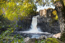
Waterfall on Bowlee Beck Downstream from Summerhill Force and Gibson’s Cave in Flood Conditions, Teesdale, County Durham, UK.
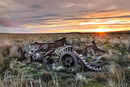
The remains of a Cruiser, Mk I (A9) Tank at Sunrise, Teesdale, County Durham, UK

Cronkley Fell and the River Tees in Winter, Teesdale, County Durham, UK

The River Tees at High Force in Autumn, Teesdale, County Durham, UK

Low Force and the River Tees in Autumn, Bowlees, Teesdale, County Durham, UK

The River Tees in Flood at High Force after a Summer Thunderstorm, Teesdale, County Durham, UK

Barnard Castle and the River Tees in Autumn, Teesdale, County Durham, UK

Steetley Pier Dawn Light, Hartlepool, County Durham, UK

Steetley Pier Dawn Light, Hartlepool, County Durham, UK

Steetley Pier Dawn Light, Hartlepool, County Durham, UK

Steetley Pier, Hartlepool, County Durham, UK

Steetley Pier, Hartlepool, County Durham, UK

Groynes near Steetley Pier, Hartlepool, County Durham, UK

Steetley Pier, Hartlepool, County Durham, UK
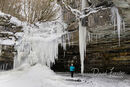
Summerhill Force in Winter, Teesdale, County Durham, UK

Rowan Berries and the River Tees near Low Force, Teesdale, County Durham, UK

Bluebell Wood, Teesdale, County Durham, UK

Summer Evening Light on the River Tees at Demesnes Mill, Barnard Castle, Teesdale, County Durham UK.

The medieval ruins of Barnard Castle reflected in the River Tees in Autumn, Barnard Castle, Teesdale, County Durham, UK

The medieval ruins of Barnard Castle reflected in the River Tees in Autumn, Barnard Castle, Teesdale, County Durham, UK

Sheep with Cronkley Fell beyond, Teesdale, County Durham, UK

Low Force and the River Tees in Autumn, Bowlees, Teesdale, County Durham, UK
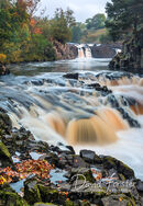
Low Force and the River Tees in Autumn, Bowlees, Teesdale, County Durham, UK


Bowes Museum Rainbow, Barnard Castle, County Durham, Uk

High Force in Autumn, Teesdale, County Durham, UK

Autumn Mist at Sunrise, Teesdale, County Durham, UK

Autumnal Colours, Bowlees, Teesdale, County Durham, UK

Blackling Hole Waterfall, Hamsterley Forest, County Durham, UK

Remember Them, Middleton-in-Teesdale, County Durham, UK

